
 Multi-frequency & multi-constellation GNSS receiver
The ProMark 800 rover and rover/base system, with its 120 channels, offer L1/L2/L5 GPS+GLONASS+GALILEO field-proven technologies for surveying and geodesy. This is a powerful RTK survey solution delivering precise GNSS positioning in a smart, rugged, cable-free and flexible design.
Advanced Z-Blade Technology
The new Z-Blade GNSS Centric technology optimally uses GNSS signals and takes advantage of each GNSS constellation to deliver fast and stable RTK positions, even when GPS coverage is insufficient, like in dense urban canyons or heavy tree canopy. Not like all GNSS receivers which prioritize GPS satellite signals over signals from other constellations, ProMark 800 with Z-Blade is no longer GPS dependent (requiring a minimum of 4 to 5 GPS satellites) to acquire and maintain precise positioning. Z-Blade GNSS Centric algorithm treats equally all available satellite signals and then combines them for optimal performance.

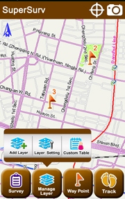 SuperSurv is the mobile GIS application specially designed for Android OS. Integrating with GIS and GPS technologies, SuperSurv allows you to easily collect and survey spatial data in the field with the mobile devices installing Android OS.The main functions of SuperSurv include data collection, orientation, map display and waypoint guidance. With the built-in GPS functions, the data of point, line and polygon can all be captured quickly. In the meantime, the waypoint and track can be recorded and managed to well control your directions.Moreover, the application supports global coordinate system settings, so the files of different regions can be displayed correctly. Besides, the data of point, line and polygon that SuperSurv collects can be saved in SHP, GEO, and KML formats for more advanced uses.
