Geoconnect is a specialist GNSS Dealer and offers Rugged Computing and Software Solutions

Spectra Precision HV 301G

Rugged Green Beam Laser System for Interior Construction

The Spectra Precision® Laser HV301G green laser beam is easy to see in interior jobsite conditions. The superior visibility of the green beam is useful for extended working ranges or in bright conditions. The beam stays visible for efficient work in these less than ideal conditions.

The versatile HV301G automatically self-levels in both the horizontal and vertical modes and can be used in a wide variety of applications.


Spectra Precision GL 512 & GL 522

Versatile Automatic Grade Lasers for Level, Grade and Vertical Alignment

The Spectra Precision® Laser GL512 single grade and GL522 dual grade transmitters are rugged, cost-effective, automatic self-leveling lasers that do three jobs—level, grade, and vertical alignment.

Both the GL512 and GL522 include a 2-way, full-function remote control with a built-in back-lit grade display. You can do everything with the remote control that you can do at the laser keypad, up to 100 m away from the laser—even from the cab of a machine!

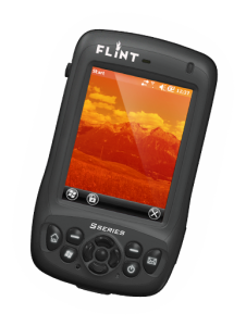
Flint S-Series

The FLINT S-Series is the next generation of high-precision, rugged handhelds designed for today’s mobile workforce. The device has built-in features such as GPS, 3G voice and data, and numerous other features that withstand harsh environments and the rigors of continuous field work. The lightweight and compact design makes the S-Series handheld a must have for any job. The S-Series offers the most up-to-date, fast and efficient mobile data collection and processing with communication options designed for all types of working environments.


ProFlex 800

Outstanding GNSS Performance in Ultra Rugged Design

The ProFlex 800 is a powerful GNSS positioning solution that delivers state-of-art RTK features in a rugged, highly integrated receiver design. The new Z-Blade GNSS centric technology uses all available satellite signals equally (without preference to any particular constellation) to deliver fast and stable RTK solutions. Z-Blade helps ProFlex 800 achieve optimal results, even in environments where GPS coverage in insufficient, like dense urban canyons or under tree canopy.   

ProFlex 800 CORS

New generation reference station

The ProFlex 800 CORS (Continuously Operating Reference Station) is the special edition of ProFlex 800 receiver adopted for CORS applications. It is the optimal solution when collecting, storing and transferring high quality GNSS raw data for post processing surveys, geodetic and other applications. Automatic sessions programming, user-friendly Web-interface, embedded RINEX converter, FTP push functionality and many other advanced CORS features make ProFlex 800 CORS a powerful, robust and easy-to-use solution. Rugged and IP67 rated, the receiver is made to withstand harsh environments.

Spectra Precision Survey Pro

Spectra Precision® Survey Pro field software provides you with a complete set of capabilities for all your survey projects. It’s fast, reliable and easy to use. Transfer data from Survey Pro to your laptop or PC and manage your jobs using Spectra Precision Survey Office. Survey Pro software ships on Spectra Precision’s rugged line of data collectors providing unparalleled integration, data integrity, efficiency and ease-of-use. The features and functions of Survey Pro have been developed based on feedback from surveyors like you. Each new release of this software incorporates enhancements built on your field experience.

Spectra Precision Recon

  • Featuring Spectra Precision Survey Pro software
  • Weighs just 490 grams (17 oz.)
  • Meets MIL-STD-810F standards
  • IP67 rating
  • Two CompactFlash (CF) slots
  • 400 MHz processor
  • Integrated Bluetooth
  • 15 hour rechargeable battery
  • Windows Mobile 6

Spectra Precision Nomad

  • Spectra Precision Survey Pro software
  • Full VGA display
  • Meets MIL-STD-810F standards
  • IP68 rating
  • Backlit Numeric keypad
  • 806 MHz processor
  • Bluetooth
  • Optional integrated GPS, Wi-Fi 802 11g, WWAN, and camera
  • 15-hour rechargeable battery
  • Windows Mobile 6.1

ProMark 800

Multi-frequency & multi-constellation GNSS receiver
The ProMark 800 rover and rover/base system, with its 120 channels, offer L1/L2/L5 GPS+GLONASS+GALILEO field-proven technologies for surveying and geodesy. This is a powerful RTK survey solution delivering precise GNSS positioning in a smart, rugged, cable-free and flexible design.

Advanced Z-Blade Technology
The new Z-Blade GNSS Centric technology optimally uses GNSS signals and takes advantage of each GNSS constellation to deliver fast and stable RTK positions, even when GPS coverage is insufficient, like in dense urban canyons or heavy tree canopy. Not like all GNSS receivers which prioritize GPS satellite signals over signals from other constellations, ProMark 800 with Z-Blade is no longer GPS dependent (requiring a minimum of 4 to 5 GPS satellites) to acquire and maintain precise positioning. Z-Blade GNSS Centric algorithm treats equally all available satellite signals and then combines them for optimal performance. 

SuperGIS Server

SuperGIS Server, a comprehensive and server-based GIS, is designed for giving the organizations the ability to create, manage, integrate and distribute a variety of GIS resources, such as maps, globes, geodatabases, tools, etc., over the Internet to support desktop, mobile and web applications. SuperGIS Server allows the organizations to infinitely share the most up-to-date GIS resources across an enterprise and across the Web.

SuperGIS Server effectively simplifies the process of accessing GIS services for GIS experts, field workers and workers without any GIS experience. With SuperGIS Server, the clients can significantly reduce the costs of data storage and purchasing software as well as the burden of data processing.