 Geoconnect has a variety of GIS Mapping and Surveying grade Subscriptions available, including Nation-wide and State-wide service. Annual subscriptions are available for the heavy user and a range of monthly and hourly subscriptions for the casual or project users.
Our services are available 24/7 through secure NTRIP connections and are open to all data formats (RTCMv3.x,RTCMv2.x, CMR, etc), offering a GNSS RTK solution to anyone in the precision measurement marketplace.
Our real-time services are built on the powerful GNSS Spider software, providing high-precision, high-availabilityRTK corrections for any application, using any constellation – and it is available to everyone. GNSS Spider makes life easy for the user through its Nearest Base and Automatic Cell technologies, all the user has to do is choose to use either a single base or network RTK solution, and Spider does the rest! By using the user’s approximate position, Spider can select the best base station(s) to use and optimise the RTK corrections for the rover’s current location.


 ADL Vantage Pro is an advanced, high speed, wireless data link built to survive the rigors of GNSS/RTK surveying and precise positioning.
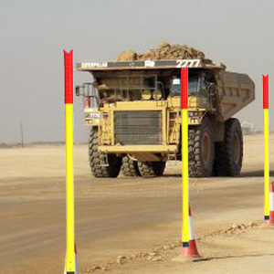 “Haul Road” Edge Marker Post:- Specifically designed to be used for Roadside Safety in Open Cut Mine haul roads. The “self-recovering”, 2.5m high posts, in White or Yellow & reflective delineation present a highly visible continuous reference point for 24hr safety for Haul Road truck drivers, as they will be able to “clearly see” the dangerous Haul Roadside edge.