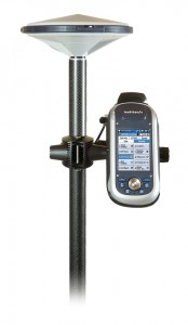
 ProMark 200 is the most cost-effective dual-frequency network RTK solution. Embedded Ashtech BLADE technology provides long-range RTK performance, fast initialization and centimeter-level accuracy. Together with the comprehensive Ashtech FAST Survey field software, the ProMark 200 meets the demanding expectations from professional land surveyors. The mix of exceptional RTK performance and compact design makes the ProMark 200 an extremely powerful and appealing network RTK rover solution.
- All-in-view, dual-frequency rover
- Fast fix with short initialization time
- Built-in wireless connectivity
- Minimal cost for maximum productivity
ProMark 200 is the most cost-effective dual-frequency network RTK rover. ProMark 200 solution includes the new Ashtech rugged GNSS receiver running Windows Mobile® 6.5 operating system, the comprehensive Ashtech FAST Survey field software and the new Ashtech ASH-661 (L1/L2 GNSS) antenna.Advanced GNSS SolutionProMark 200 – dual-frequency, all-in-view network RTK rover – with the embedded Ashtech BLADE technology delivers a long-range RTK performance, fast-initialization time, and high-precision. For specific survey applications it can provide outstanding real-time centimeter-level accuracy even in handheld configuration.Designed For Efficient Network RTKVery lightweight, with compact and rugged design, as well as large memory and autonomy, ProMark 200 has been designed for a confortable and productive field use. Its extended wireless communications (Bluetooth, Wi-Fi) and embedded GSM/GPRS modem make ProMark 200 a powerful solution suitable for any network RTK applications.
Best Value For A High-End Survey Solution
ProMark 200 is extremely cost-effective offering meeting the most demanding requirements for a high-end survey solution. Together with FAST Survey, it provides possibility to interwork with a wide range of survey instruments and accessories to run complete survey jobs, including site calibration, stake out, and survey projects where total stations are used.
Specification
- Constellation :GPS, GLONASS, SBAS
- Frequency :L1, L2
- Channels :45
- Update Rate :0.05 sec
- Data format :RTCM 3.1, ATOM, CMR(+), NMEA
- Raw data output :Yes
- Real-time Accuracy – RTK mode (HRMS) :1 cm
- Real-time Accuracy – DGPS mode (HRMS) :< 30 cm
- Real-time Accuracy – SBAS mode (HRMS) :< 50 cm
- Post-Processed Accuracy (HRMS) :0.5 cm + 1 ppm
- Time to first fix :15 sec
- Initialization range :Up to 40 km
- Processor :806 MHz
- Operating system :Windows Mobile 6.5
- Communications :GSM/GPRS, BT, WLAN
- Unit size (mm / inches) :190x90x43mm / 7.5×3.5×1.7in
- Weight :0.62 kg / 1.43 lb
- Display :3.5
- Memory :256 MB SDRAM / 2 GB NAND / SDHC
- Temp Min (°C) :-20°C / -4°F
- Temp Max (°C) :60°C / 140°F
- Waterproof :IP 65
- Shock & vibration :ETS300 019 & MIL-STD-810
- Power (type – lifetime) :6600 mAh Li-Ion / > 8 hrs
- Antenna Type :Internal / External
- Firmware options :Yes
- Software options :Yes
 ProMark 200 Brochure (1.5 MiB)
 MM100-PM100-PM200 Family Brochure - Geoconnect (1.2 MiB)
